
The big thing with the marquise if i recall is that it has-10s in it so lots more jam up top
http://www.aopa.org/Pilot-Resources/Air ... bishi-MU-2
Crash at Iles-de-la-Madeleine
Moderators: sky's the limit, sepia, Sulako, lilfssister, North Shore

Re: Crash at Iles-de-la-Madeleine
This mu2 likely left the factory with one radio altimeter. Whether it was still installed/functional/or properly used is another question. (Arguably not properly used in this case!). This plane was built in the early 80s, so things like Synthetic or Enhanced vision were not original equipment, although there are some aftermarket option to add this technology. I somehow doubt this particular airframe had that upgrade. Interestingly, the fact that this flight only carried 5 passengers means that it did not require a TAWS-B system by both TC and FAA rules.CpnCrunch wrote: Wouldn't an expensive plane like this at least have a radar altimeter, synthetic vision or something?
Speaking of rules, under TC this airplane requires the pilot to have a type rating (as it falls in the high performance category). Under FAA rules, the pilot requires special training under SFAR 108. Does anybody know if the accident pilot met either of these requirements?
This brings up a conundrum for someone with more knowledge of the CARs/FARs: since the aircraft was operated in Canada, did the crew have to meet the FAA requirements (it was still a US registered aircraft). But if it had been a Canadian registered aircraft of this type, it would have had to have been operated under a 604 POC or 703 AOC.
I think we can all agree on most of what was said here.

Re: Crash at Iles-de-la-Madeleine
That part isn't too hard. Figure on about 7700 lbs BEW, add 1400 lbs of passengers and crew, 300 lbs of baggage, you're up to 9400 lbs ZFW; 11625 max ramp weight means you've got room for 2225 lbs of fuel.andy_mtl wrote:Ok folks lets have a look at the flight from the beginning.
This was a marquise carrying 7 people, and fuel to get to la madeleine. First question that comes to mind is:
How did they put 7 people , fuel there plus ifr alternate in it?
Having flight planned mu2 flights very often at my previous job, i m having a hard time believing they were not complying with MTOW. Again i just tried running the numbers with the empty weight of one of the mu2 i used to fly.
YHU-YGR is 494 NM, at 300 kts groundspeed takes about 1:45. At 700 lbs for the first hour, and 600pph for the second, that gives you 1150 lbs of burn to destination. Add 50 lbs for start/taxi, and 500 lbs for IFR reserve, you have 525 lbs of fuel left for alternate/contingency. YQM is only about a 30 minute flight from YGR, so 350 lbs of alternate fuel, and 175 lbs of contingency fuel seems pretty reasonable.
The Marquise is simply the last version of the long body MU-2 built. There were 2 basic MU2 body styles, long and short, and each revised mark included both a long and a short version. As mentioned, the MU-2B-60 (Marquise) featured TPE 331-10 engines, which are essentially 1000 hp engines derated to 715 SHP. It also has SRL computers to simplify engine management, whereas earlier models had ITT or compensated EGT indicators. Most Marquise were delivered with Sperry SPZ-500 autopilots, although the earliest ones had slightly less advanced Bendix M4D autopilots.Antique Pilot wrote: What are some of the basic differences between a regular MU2 and the Marquise version? Like performance, SE handling, etc?
Thanks
AP
-
Midnight Sun
- Rank 0

- Posts: 1
- Joined: Fri Apr 01, 2016 8:00 pm
Re: Crash at Iles-de-la-Madeleine
I'm guessing they were really counting on that 800' TEMPO possibly coming through? For a more experienced pilot, and a different A/C, I would say there's nothing wrong with giving it a try, as long as someone is willing to foot the bill given the high chance you'll end up at your alternate. I'm not sure about his experience (and especially on type), but it doesn't sound like a situation someone without a lot of time on the MU-2 would want to be in.daedalusx wrote:Airport served only by NPA which according to the winds would have been RWY 07 with a MDA of 480 (458). Why even bother attempting the approach when the reported ceiling is 200' ?...
TAF CYGR 291341Z 2914/3002 05030G40KT 11/2SM -RASN BR OVC003 TEMPO 2914/2917 3SM -RA BR OVC008 PROB30 2916/2917 3/4SM -SN BLSN VV006 FM291700 01040G55KT 3/4SM -SN BLSN VV006 TEMPO 2917/2923 21/2SM -SN BLSN OVC010 BECMG 2919/2921 35045G60KT FM292300 34040G50KT 11/2SM -SN BLSN BKN025 RMK NXT FCST BY 292000Z
")
Re: Crash at Iles-de-la-Madeleine
http://www.cbc.ca/news/canada/montreal/ ... -1.3517938
...
...
..Shortly before 12:30 p.m. AT, either Gosselin or his co-pilot Fabrice Labourel radioed air traffic control in Moncton, N.B. Their plane was cleared for an instrument approach to Runway 07 at Îles-de-la-Madeleine Airport.
It was raining lightly on the archipelago. There was mist. Gosselin wasn't likely able to see more than four kilometres in front of him.
His MU-2B approached the runway from the southwest, but at some it began to lose altitude, enough to alarm those who live nearby.
"I heard the sound of a plane flying low, low, low," said Diane Vigneault. "I said to myself, 'That plane is so low.' I cried, I didn't know what else to do."
Eyewitnesses say the plane's nose was pointed downward, though the preliminary evidence gathered by the TSB suggests its wings were roughly horizontal to the ground.
"We know that the plane wasn't in a serious nose-dive," said André Turenne, a senior investigator with the TSB.
"It was relatively horizontal. It was rolling slightly to the left."
Around 12:30 p.m. AT the plane's left wing and engine struck ground some two kilometres from the runway. The plane skidded the length of a football field before coming to rest near a cluster of homes.
-
costermonger
- Rank 8

- Posts: 881
- Joined: Fri Apr 15, 2005 7:52 pm
Re: Crash at Iles-de-la-Madeleine
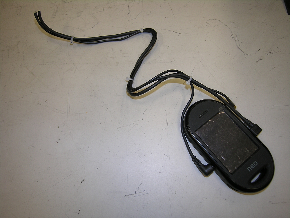
This should help the investigative process along dramatically. Intercom, ambient noise, GPS position and accelerometers, and it looks intact. Hopefully it was working.

Re: Crash at Iles-de-la-Madeleine
There was no question that one of those would be on board. Pascal was both the pilot of the MU-2 in question as well as the CEO of the company that produced that flight data recorder.costermonger wrote:
This should help the investigative process along dramatically. Intercom, ambient noise, GPS position and accelerometers, and it looks intact. Hopefully it was working.
Re: Crash at Iles-de-la-Madeleine
I have flown on this plane once. As far as the wrong altimeter theory goes, it is not impossible, nothing can be ruled out, but that plane had TAWS, radar alt, and the G750 would certainly have been flashing yellow and red if 1,000 below indicated altitude on approach
-
costermonger
- Rank 8
- Posts: 881
- Joined: Fri Apr 15, 2005 7:52 pm
Re: Crash at Iles-de-la-Madeleine
Agreed, that product is why I knew him. But they're not exactly hardened, so it's good to see it's intact.C-GKNT wrote:There was no question that one of those would be on board. Pascal was both the pilot of the MU-2 in question as well as the CEO of the company that produced that flight data recorder.
-
Siddley Hawker
- Rank 11

- Posts: 3353
- Joined: Tue Aug 10, 2004 6:56 pm
- Location: 50.13N 66.17W
Re: Crash at Iles-de-la-Madeleine
I saw somewhere that the debris field was less than a hundred meters long. Sounds kinda short, what would the airplane be doing on approach, 120 kt?
Re: Crash at Iles-de-la-Madeleine
I think I saw 140 somewhere back in the thread. I thought the debris trail was short for an airplane that seems to have been wings level at contact, but one or both wings are busted off. and the left side elevator has some ripping that is a bit odd, so perhaps it did a fair bit of tumbling before it came where it is in the pictures. There's little hillocks in there and it may have run into them as well.Siddley Hawker wrote:I saw somewhere that the debris field was less than a hundred meters long. Sounds kinda short, what would the airplane be doing on approach, 120 kt?
Good judgment comes from experience. Experience often comes from bad judgment.
Re: Crash at Iles-de-la-Madeleine
Had a look at the TSB photos. There is a lot of compression lengthways on almost all the fuselage, Left side bottom. It looks like the right prop cut into the fuselage, and the left elevator is entirely separated about 50 yards or so behind the wreckage, but on the right side of the trail.
Although the aerial of the skid trail looks like it was just on its belly, I think there must have been quite a lot of things happening along the way. The wreckage was going uphill when it stopped.
Although the aerial of the skid trail looks like it was just on its belly, I think there must have been quite a lot of things happening along the way. The wreckage was going uphill when it stopped.
Last edited by cncpc on Tue Apr 12, 2016 12:46 pm, edited 1 time in total.
Good judgment comes from experience. Experience often comes from bad judgment.
Re: Crash at Iles-de-la-Madeleine
I've composited photo 9 from the TSB onto a Google image of where the airplane ended up. It was 400 yards to the right of the localizer, which is shown in yellow at top left. The ground marks trail is on a heading roughly 80 degrees off inbound heading. The elevation of the site is 50 ASL. There is a 100 foot hill just ahead on the direct path to the airport.
People saw the aircraft, so he must have seen those houses, 50 to 100 feet below him. He was over 400 feet below minimums assuming he was using the LOC/DME 07.
People saw the aircraft, so he must have seen those houses, 50 to 100 feet below him. He was over 400 feet below minimums assuming he was using the LOC/DME 07.
- site idelam.jpg (295.48 KiB) Viewed 5482 times
Good judgment comes from experience. Experience often comes from bad judgment.
Re: Crash at Iles-de-la-Madeleine
Is the red line the impact path? We're they going away from the loc?
Re: Crash at Iles-de-la-Madeleine
Yes, the skid trail in TSB photo 9. I think it is.av8ts wrote:Is the red line the impact path? We're they going away from the loc?
They were in sight out of cloud passing the shoreline over the old convent there, but converging with the localizer. They had to be well below minimums there as well, or they had some instrumentation or icing problems.
You would think, all other things being equal, that if you look down and see a rooftop 50 feet below you, you are going to go to max power and center the needle. Which leads to the thought/conclusion that all things weren't equal.
That heading is about 150 magnetic. The inbound track for the loc appch is 074. So 75 off. It doesn't really make sense within the framework of a fully functioning airplane making an instrument approach.
Is there any radar track for that flight?
Good judgment comes from experience. Experience often comes from bad judgment.
Re: Crash at Iles-de-la-Madeleine
No radar over therecncpc wrote: Is there any radar track for that flight?
Re: Crash at Iles-de-la-Madeleine
What would prevent understanding the aircraft was actually on the approach for which the clearance was given ? ... which is on the localizer (above photo in yellow) for runway 07 immediately before the accident.
Eyewitness says plane is "nose down" before crash. TSB says looks like 'slightly noseup' and mostly level at crash. Maybe ice catch, maybe none. Above post by Cncpc shows the "football-field size" groundscar is oriented 80degrees-right off the final (70M heading)... "150M". Leaves only the lingering question about stronger landingwinds low-over / lee-of the hill right there.
EDIT:
Av8s, the 150M is quoting cncpc (the ground mark aligns 80deg right off the approach); the strength of the component is given at the airport ahead (TSB rep) 37kph gusting 56. Yet the TAF had 50-60kt gusts expected. Since the accident sequence is higher and lee of that hill, the groundspeed slows first if 50-60kts in fact up higher ... where then descending into the the lee effect (right there) cuts the airspeed much more behind that hill ... at that accident site (perhaps even if no icing handicap at all ?).
Last edited by pdw on Sun Apr 17, 2016 6:18 pm, edited 1 time in total.
Re: Crash at Iles-de-la-Madeleine
pdw wrote:What would prevent understanding the aircraft was actually on the approach for which the clearance was given ? ... which is on the localizer (above photo in yellow) for runway 07 immediately before the accident.
Eyewitness says plane is "nose down" before crash. TSB says looks like 'slightly noseup' and mostly level at crash. Maybe ice catch, maybe none. Above post by Cncpc shows the "football-field size" groundscar is oriented 80degrees-right off the final (70M heading)... "150M". Leaves only the lingering question about stronger landingwinds low-over / lee-of the hill right there.
EDIT:
Av8s, the 150M is quoting cncpc (the ground mark aligns 80deg right off the approach); the strength of the component is given at the airport ahead (TSB rep) 37kph gusting 56. Yet the TAF had 50-60kt gusts expected. Since the accident sequence is higher and lee of that hill, the groundspeed slows first if 50-60kts in fact up higher ... where then descending into the the lee effect (right there) cuts the airspeed much more behind that hill ... at that accident site (perhaps even if no icing handicap at all ?).
Sure, what you say is quite probable. Or plausible.
That scar, which seems to show a hard initial contact, is 91 m long according to TSB. It's a puzzle why its on that heading, but it is and the TSB will likely tell us why.
The TSB photo is accurately located on a 13 year old Google image, and it appears quite a few houses have been added since then.
If he was on the localizer, he wasn't on crossing the close shoreline. But he was heading towards the airport. The accident site is on a straight line between where he was seen and the airport.
If he was flying a proper approach, he'd have been somewhere between 800 and 450. He was at about 200 feet crossing the shoreline. He would have seen how low he was.
Hopefully that gadget in the photos turns out to be working.
Good judgment comes from experience. Experience often comes from bad judgment.
Re: Crash at Iles-de-la-Madeleine
If the airlines are going in there regularly, then it was certainly working.
EDIT Fri Apr22:
(re Trampbike's post below)
They're not catching up to the gusting here either, as that 30kt component was on the nose ( NE "37kph at 56kph")
EDIT2: But there IS a strong airspeed-decay factor in existance with that 30 knot plus component ( higher up is even stronger ) when in descent immediately in front of the terrain located short of this airport's runway 07 threshold.
Though, maybe not reliable when the "100' hill" ahead distorts the beam's accuracy on a low-enough approach ?cncpc wrote: He was at about 200 feet crossing the shoreline.
EDIT Fri Apr22:
(re Trampbike's post below)
They're not catching up to the gusting here either, as that 30kt component was on the nose ( NE "37kph at 56kph")
EDIT2: But there IS a strong airspeed-decay factor in existance with that 30 knot plus component ( higher up is even stronger ) when in descent immediately in front of the terrain located short of this airport's runway 07 threshold.
Last edited by pdw on Tue Apr 26, 2016 5:12 pm, edited 2 times in total.