Today we heard a light cessna calling on 133.35 that it was lost and running low on fuel. The pilot called terminal for help with directions but was below radar altitude and "didn't have enough fuel to climb from A064 to A085".
Last we heard the pilot announced that they were almost out of gas and were doing a precautionary. They confirmed it was a field, not water and then no other calls were heard.
Terminal had a bunch of aircraft relaying trying to reach them, but when we left the frequencies no one had heard from them.
My heart really goes out to the guy. The controller tried giving them instructions on using the VOR but it sounded like they didn't know how. The controller only knew that they were between Lillouet and Kamloops.
Does anyone from 'M' at Boundary bay know the outcome?
I'd really like to know what happened, we spent about 20 minutes deviating trying to help reach them.
Thanks,
ptp
Anyone know what happened to QRR today?
Moderators: North Shore, sky's the limit, sepia, Sulako, lilfssister, I WAS Birddog
-
The Dark Side
- Rank 0

- Posts: 9
- Joined: Sun Dec 24, 2006 10:08 am


-
invertedattitude

- Rank 10

- Posts: 2353
- Joined: Tue Jul 06, 2004 1:12 pm

-
Highflyinpilot
- Rank 8

- Posts: 865
- Joined: Wed Apr 21, 2004 10:30 am
- Location: Holy Hell, is that what you look like in the morning

-
Siddley Hawker
- Rank 11

- Posts: 3353
- Joined: Tue Aug 10, 2004 6:56 pm
- Location: 50.13N 66.17W
From what I heard on the radio while it was happening, the pilot (sounded like a Chinese student) made a full may-day call saying he had an engine failure due to no fuel and was going to do a forced approach. He couldn't identify where he was, and radio contact was lost before radar contact was established.
I heard the next day on the radio, they located the aircraft near 108 Mile House.
Nonetheless, looks like a good job getting it on the ground and I'm glad everyone is safe!
I heard the next day on the radio, they located the aircraft near 108 Mile House.
Nonetheless, looks like a good job getting it on the ground and I'm glad everyone is safe!
Last edited by Ralliart on Wed Sep 12, 2007 9:23 pm, edited 1 time in total.
Yeah, he was contacting terminal looking for help with directions and elected to do a precautionary. But he must have been LOW if he didn't want to risk climbing 2000' more feet to be picked up on radar.
I know my co-workers heard others making calls for an hour after trying to contact them.
Good work for the kid to realize he needed to land and make it happen. I heard from another friend in the 'instructing business' that they landed in a 1000' field with no damage. Good for them, too bad people are going to get shit on by an owner for something that could have ended a lot worse.
As an aside, perhaps putting off the elt once they decided to land off airport would have made the search easier. Also, instructors please recognise the beautiful simplicity of the adf.

I'd just like to say, good work to the renter/student on getting to the ground safely.
What I hope, is that this incident will not affect this pilot into not flying anymore, but rather teach a lesson on fuel management etc. to help make him/her a better pilot. I find it a shame sometimes, when a pilot quite flying (especially a low timer) after an incident like this. I do however support his/her decision to continue or not, because we do all react differently post-incident like that.
Again, great work getting er' down safely!
FY
Flying is the second greatest thrill in life... landing is the first.
Take my love, take my land, take me where I cannot stand. I dont care, Im still free. You cant take the Sky from me
Take my love, take my land, take me where I cannot stand. I dont care, Im still free. You cant take the Sky from me
From CADORS:
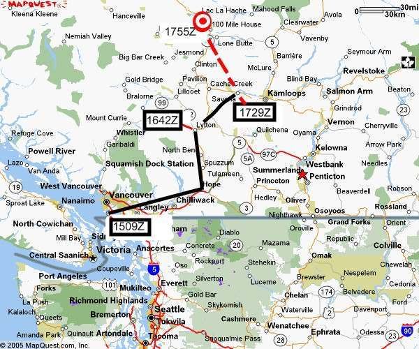
The pilot of the Montair Aviation Cessna C150 filed a VFR flight plan from Boundary Bay to Kamloops (CYKA), with a departure time of 1509Z and an ETA in CYKA of 1800Z with 0430 endurance. He called CYKA Flight Information Centre at 1642Z reporting over Lytton. He called at 1729Z reporting 3 South of Kamloops Lake. At 1750Z he called to say he was lost and requested help in orientation. Because he was unable to provide sufficient information, he was asked to contact Vancouver ACC. The pilot contacted Vancouver ACC at 1751Z at 6,200 feet, which was below radar coverage. He was asked if he could climb but stated he was unable because he was very low on fuel. At 1755Z the pilot broadcast a MAYDAY stating he was landing on a farm field by a highway. No other information was provided. The Rescue Coordination Centre (RCC) was alerted. Aircraft were tasked to Williams Lake, ELT composite was formed and aircraft tasked to ELT area. The aircraft was eventually located at 2025Z 20 NM Northeast of 108 Mile Ranch on a farm field (5154.64 12109.17). There was no persons on board. The company called RCC to advise they were in contact with the pilot and everything was safe and sound. No damage or injuries were reported.
The pilot of the Montair Aviation Cessna C150 filed a VFR flight plan from Boundary Bay to Kamloops (CYKA), with a departure time of 1509Z and an ETA in CYKA of 1800Z with 0430 endurance. He called CYKA Flight Information Centre at 1642Z reporting over Lytton. He called at 1729Z reporting 3 South of Kamloops Lake. At 1750Z he called to say he was lost and requested help in orientation. Because he was unable to provide sufficient information, he was asked to contact Vancouver ACC. The pilot contacted Vancouver ACC at 1751Z at 6,200 feet, which was below radar coverage. He was asked if he could climb but stated he was unable because he was very low on fuel. At 1755Z the pilot broadcast a MAYDAY stating he was landing on a farm field by a highway. No other information was provided. The Rescue Coordination Centre (RCC) was alerted. Aircraft were tasked to Williams Lake, ELT composite was formed and aircraft tasked to ELT area. The aircraft was eventually located at 2025Z 20 NM Northeast of 108 Mile Ranch on a farm field (5154.64 12109.17). There was no persons on board. The company called RCC to advise they were in contact with the pilot and everything was safe and sound. No damage or injuries were reported.
He departs at 1509 with 4.5 hours of fuel for a 3 hour flight (ETA 1800). Declares an emergency at 1755 2.8 hours later, out of fuel.
Even if he didn't get lost he would of ran out of fuel before reaching his destination.
So is this a issue with planning the wrong fuel burn or departing with less fuel then planned?
Lurch
Even if he didn't get lost he would of ran out of fuel before reaching his destination.
So is this a issue with planning the wrong fuel burn or departing with less fuel then planned?
Lurch
Take my love
Take my land
Take me where I cannot stand
I don't care
I'm still free
You cannot take the sky from me
Take my land
Take me where I cannot stand
I don't care
I'm still free
You cannot take the sky from me
A standard capacity 150 (26 gallons total, less than that usable) doesn't have 4.5 hrs at normal cruise.
I suspect the poor kid took off with a few gallons shy of a full load (Cessnas are famous for that), he probably didn't lean in the climb, he probably didn't lean aggressively in cruise, so he burned 7 gal/hr instead of 6 gal/hr, and after he used 21 gallons or so (2.8 hrs) down he went.
Once you get a fuel flow/totalizer, there's no going back.
-
jon_upsidedown
- Rank 1

- Posts: 16
- Joined: Tue Sep 11, 2007 1:59 pm
- Location: B.C.
My question is
"How did he take his 152 from Kamloops lake to 108 mile house in 20 mins?"
"How did he take his 152 from Kamloops lake to 108 mile house in 20 mins?"
Last edited by jon_upsidedown on Sat Oct 20, 2007 7:38 pm, edited 1 time in total.
-
ScudRunner
- Rank 11
- Posts: 3239
- Joined: Tue Jun 08, 2004 11:58 am
 [/img]
He didn't. He obviously thought he was somewhere he wasn't. If he found Kamloops Lake and was VMC, he'd have a hard time not finding Kamloops. If he followed the Thompson up to from Lytton to Cache Creek, continued towards Clinton rather than turning east, there are a couple lakes northeast of Clinton he might have confused with Kamloops Lake. 20nm northeast of 108 mile from 3 south of Green Lake, say, seems much more reasonable in 20 minutes.jon_upsidedown wrote:My question is
"How did he take his 152 from Kamloops lake to 108 mile house in 20 mins?"
Not saying that's what happened, just that he likely never was at Kamloops lake.

-
Masta-Fred
- Rank 2

- Posts: 58
- Joined: Wed Jul 11, 2007 4:26 pm
- Location: 200' from threshold RW07
heres my 2cents i remember from memory,, he got to hope no problem,,, easy enough he goes north... uses lytton as his marker to turn east,, however he uses the lytton airport THINKING hell see an actual paved runway.. to his surprise there is no paved runway in lytton its an abandonned dirt almost sandy like strip.. totally misses it.. keeps going north until he hits Lillooet where a paved runway with an "opening" in the rockies to the east.. . he takes that "opening" to the east goes north... towards 108 mile or CYWL or wherever... notices hes lost once he gets into a clearing due to the fact that his planning had no major openings in it..
thats just my thought on what happenned
thats just my thought on what happenned