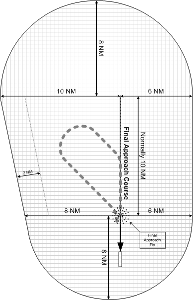
Can someone tell me what the horizontal protected airspace is on both the protected and non protected side of the Precision/non-precision approach is please. Assume 10 nm pt from FAF.
Thanks
Procedure Turn protected airspace.
Moderators: lilfssister, North Shore, sky's the limit, sepia, Sulako, I WAS Birddog
-
West Coast Swell
- Rank 3

- Posts: 117
- Joined: Sat Mar 13, 2004 8:46 am

-
angry inch
- Rank 7

- Posts: 518
- Joined: Fri Jan 07, 2005 10:18 pm
- Location: the wet coast
Re: Procedure Turn protected airspace.
I'm curious where those diagrams came from... they just don't make sense in all cases. Take CYXP (Pangnirtung) for example, or even CYCY (Clyde River)... at PT altitude you would definitely hit granite if you followed those diagrams to a T.
Just saying.
Just saying.
-
angry inch
- Rank 7
- Posts: 518
- Joined: Fri Jan 07, 2005 10:18 pm
- Location: the wet coast
Re: Procedure Turn protected airspace.
The bottom one is straight from the instrument procedures manual. I see what you mean with the spot heights on the Pang plate.
Re: Procedure Turn protected airspace.
I'm not sure that I agree with the certainty here.station60 wrote:I'm curious where those diagrams came from... they just don't make sense in all cases. Take CYXP (Pangnirtung) for example, or even CYCY (Clyde River)... at PT altitude you would definitely hit granite if you followed those diagrams to a T.
Just saying.
In the case of CYXP the PT alt is 4000' The spot heights that are likely the ones that concern you are the 4836 and the 3970. In those directions, the PT only provides terrain clearance for obstacles within 8 NM of the NDB. Looking at the diagram the 3970 point looks to be more than 8 NM from the NDB. The 4836 looks pretty close but it also appears to be the tip of some very rapidly rising terrain, based on the contour lines. I'm only looking at the approach plates and approximating and not measuring. I would imagine that the 4836 point (and the associated rising terrain) is very close to, but just outside the 8 NM zone covered by the PT "beyond" the NDB. In the other directions, from the approach plate, the 4000' clears all obstacles by at least 1000'. I can't see much beyond the 10 NM procedure turn area but it looks like that heads off to open water so I'll assume that there is adequate terrain clearance in that area.
YCY is an interesting case. At first glance it looks like the entire area on the procedure turn side of the NDB provides the required terrain clearance at the 1600' PT altitude. (Again, I'm assuming that beyond the 10 NM procedure turn area is open water.) The issue appears to come from the 1572 spot height beyond the NDB. This is clearly within 8NM of the NDB and does not meet the terrain clearance requirements of the PT altitude. This is why they add the additional altitude of 2600' on the "upwind" side of the NDB. This is how they handle obstacles that impinge on the obstacle clearance surface beyond the NDB. (There are likely other approach procedures in similar terrain that have similar issues. I imagine that those that operate in BC deal with it as well.)
Based on what I see from the approach plates it looks like if you did fly that area to a "T' you would be safe. In the case of YXP, if you wandered, even slightly, outside of that area it's likely an entirely different story.....

Re: Procedure Turn protected airspace.
If a PT is listed as "within 8 NM of" the fix, you can be 100% certain there's an obstacle just outside the area protected by the 8NM zone - otherwise it would be listed as within 10 NM - as most are.
By the way the document you want is TP 308 – Criteria for the Development of Instrument Procedures. I don't think you can download it from TC but you could get hold of a copy somehow.
By the way the document you want is TP 308 – Criteria for the Development of Instrument Procedures. I don't think you can download it from TC but you could get hold of a copy somehow.
DId you hear the one about the jurisprudence fetishist? He got off on a technicality.