Bob has to be one of the smartest individuals I've ever met. He knows his stuff, simple as that. He has been studying emergencies and analyzing situations for years, and theres no doubt in my mind that he made the absolute best decision(s) during the flight. If there was a problem with the plane, Bob knew the best way to handle it. Even if that means a forced landing on the side of a mountain in antarctica.
A Twin Otter aircraft has landed at the Beardmore Glacier, Antarctica, about 50km away from the site of a beacon activated by a missing aircraft, also a Twin Otter, at 10pm on Wednesday night (NZ time).
The Rescue Coordination Centre New Zealand (RCCNZ) is coordinating the search and rescue mission, working with United States and Canadian authorities. No visual sightings of the missing aircraft have been possible since the beacon activation, due to low cloud in the area.
RCCNZ Search and Rescue Mission Coordinator Tracy Brickles said the intention was to set up a forward base at the Beardmore Glacier location. Two helicopters, including a Southern Lakes helicopter on contract to Scott Base, are en route and expected to arrive at around 4pm (NZ time).
.
A C-130 Hercules aircraft is circling the beacon activation site, also attempting to make visual contact, and will then land with supplies at the Beardmore Glacier site. A DC3 aircraft carrying further supplies is also en route.
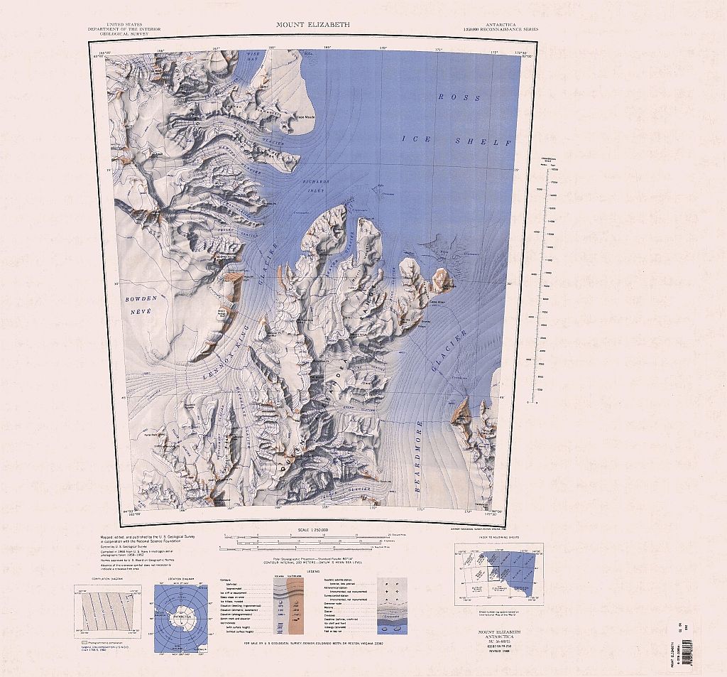
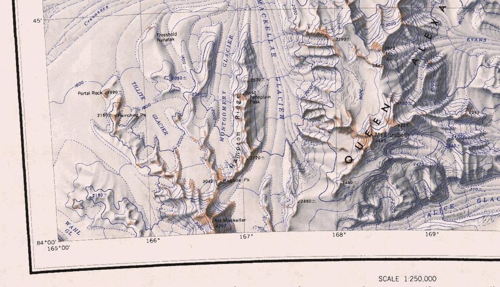
The beacon activation site is at a height of 3,900m (13,000 feet) at the northern end of the Queen Alexandra Range, within New Zealand’s Search and Rescue Region – halfway between the South Pole and McMurdo Station (approximately 680km or 370 nautical miles in each direction).
The crew of the missing aircraft are understood to have survival equipment and sufficient food supplies for five days.
WRT Satellite Phones - can anyone 'in the know' say if there's 100% satellite coverage over Antarctica? Is it conceivable that if they are on the 'wrong' side of the mountain, then the phone would not work due to lack of coverage?
squawk wrote:Thoughts and Prayers for the Crew. Click on attached "Bush Pilot Song" By Dave Hadfield. Top Right. Makes me think of Bob and Crew. God Speed!
North Shore wrote:WRT Satellite Phones - can anyone 'in the know' say if there's 100% satellite coverage over Antarctica? Is it conceivable that if they are on the 'wrong' side of the mountain, then the phone would not work due to lack of coverage?
Hoping for the best.
My experience with on board sat tracking is that it pretty well works off of the same system as the phone.
One could safely assume if the tracking was working the sat phone would work.
I've never met Bob but I pm'd him earlier today. It'll feel pretty good when that last message goes from the 'outbox' to the 'sent messages' bin.
Cheers,
North Shore I was talking to our mutual friend in Gimli last night - who has a great deal of experience down there - and he posed the same question you have. I didn't have an answer. He is also of the opinion that if the airplane didn't fly into a mountain, the guys are ok. Hope to hell he's right.
Does anyone know the actual Lat and long? The reports all say "the north end of the Queen Alexandra Range at an altitude of 13,000 feet" but from what I can see the high terrain is at the South end of Queen Alexandra Range.
TA/RA wrote:New Update:
26 January 2013, 8.30am
Efforts to locate three Canadians who’ve gone missing during a flight from the South Pole to Terra Nova Bay in Antarctica will continue today, as weather conditions improve.
The Rescue Coordination Centre New Zealand (RCCNZ) is coordinating the search, working with United States and Canadian authorities, after the missing Twin Otter aircraft’s emergency locator transmitter was activated at about 10pm on Wednesday, 23 January.
A Twin Otter aircraft is scheduled to fly from the Darwin glacier area this morning to Beardmore glacier base, which is about 50km away from where the emergency beacon was transmitting, to set up camp. As soon as the weather clears, two helicopters based at McMurdo station will be flown to the camp to undertake an aerial search for the missing plane.
Despite several planes searching for the aircraft since the beacon was activated on Wednesday night at 10pm no visual sightings have been possible due to poor visibility and snow.
The location is at a height of 3,900m (13,000 feet) at the northern end of the Queen Alexandra Range, within New Zealand’s Search and Rescue Region – halfway between the South Pole and McMurdo Station (approximately 680km or 370 nautical miles in each direction).
The Rescue Coordination Centre New Zealand (RCCNZ) said the crew of the missing aircraft have survival equipment and are well trained for the harsh environment.
An update on the search and rescue effort will be provided on the Maritime New Zealand website as soon as there are any further developments.
North Shore wrote:WRT Satellite Phones - can anyone 'in the know' say if there's 100% satellite coverage over Antarctica? Is it conceivable that if they are on the 'wrong' side of the mountain, then the phone would not work due to lack of coverage?
Could be. I've had reception issues on the coast when in the lee side of a hill with the satcom in the twin otter, on a day of good coverage! Also, as they are panel mounted, an electrical fault or failure could be attributed to the lack of communication as well. There are many many survivable scenarios. I'm still of the belief that Those three gents are sitting there telling stories in the tent waiting for the arrival of some help.
Lost in Saigon wrote:Does anyone know the actual Lat and long? The reports all say "the north end of the Queen Alexandra Range at an altitude of 13,000 feet" but from what I can see the high terrain is at the South end of Queen Alexandra Range.
Note; it is now just after 10pm Toronto time, which means it is just after 4pm Saturday afternoon in the rescue theatre. Both helicopters and Alpine rescue crew should be at the base camp.
A reminder that it is 24 hours of daylight in Antarctica this time of year.
Bob and crew will be on my mind tonight, I hope for a very positive outcome - rescuers are close by now, and just need that window of opportunity to get in there.
Goodspeed Bob - hope you and your crew are well covered, warm and awaiting a safe return.
Rob Reid
Toronto
I've heard the area described as a reverse Grand Canyon.
meflypretty wrote:Google maps doesn't give a lot of resolution but I see lots of surviveable terrain.
Correct.
Google shows that lat long at 7500 feet and it appears to be on a light upslope rising about 300 in a mile, at least to the east. But it is Google.
There is nothing above about 11,700 in that range, according to Google.
You can't appreciate the Trans Antarctic range until you've actually flown over it. Google is extremely innacurate for Antarctica. Trust me, they could be in a really bad spot or a fairly good spot. And anything in between.
meflypretty wrote:Google maps doesn't give a lot of resolution but I see lots of surviveable terrain.
Correct.
Google shows that lat long at 7500 feet and it appears to be on a light upslope rising about 300 in a mile, at least to the east. But it is Google.
There is nothing above about 11,700 in that range, according to Google.
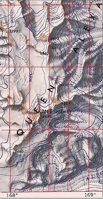
About 15 nautical miles WSW of the position given in the article there's a plateau with elevations above 12,600 at it's northern edge. 84° 1'13.12"S 166°38'46.89"E. I'd been assuming (just from the 13,000' info) the ELT signal was coming from somewhere on this plateau.
blueoval56 wrote:You can't appreciate the Trans Antarctic range until you've actually flown over it. Google is extremely innacurate for Antarctica. Trust me, they could be in a really bad spot or a fairly good spot. And anything in between.
I believe this. With google earth and other resources being so normal now, it's struck me how odd it seems to have a patch of the planet for which it's very hard to find, say, a picture.
---------- ADS -----------
Last edited by costermonger on Fri Jan 25, 2013 8:43 pm, edited 1 time in total.
If that lat/long is correct then its on a spur descending almost due east from the southern end of Mt Elizabeth. It's between the 2400 and 2600m contour.
Mt Elizabeth is 3.5nm to the NW at 4480m and its north peak 3.5nm due north of the site at 4389m.
Is their any information as to what the winds would have been at their altitude at the time of the flight? They can't have been the reported 90 mph when the first aircraft went in. It seems to me it would have been just wild in that terrain.
Can anyone express an opinion as to why they would route over this mountain range (other than it is direct) rather than go a slight bit out of the way to curve around the higher terrain to the left (west)?
If they are at 13,000, what issues arise from the altitude, other than the cold?
And, what are those meandering broken lines that we use for trails on our maps up here?


")


