
After some time from being away from IFR I am slowly getting back into it. Don't have my instrument rating yet but would like to get this done sooner rather than later.
Question, in reviewing what certainly appears to be newly designed approach plates I have a question on the following plate. NDB RWY 26 at CYKF (I see this applies to many other plates I have reviewed recently as well).
From my initial review it would appear that the procedure turn altitude is 3100' ASL, once established on the final approach course I can descend to 2200' ASL until the FAF (ZKF NDB) and then down to 1700' ASL MDA (straight in or circling). However, I see HAMES (intersection) noted on this plate and there is an altitude noted directly under it at 3370' ASL. Also, under the depicted "cone" showing the NDB there is an altitude noted of 2320' ASL. Would appreciate an explanation of what these altitudes represent. Does it have something to do with a 3 deg approach slope? As a secondary question, why wouldn't the approach plate also show this as a (GNSS) for a GPS overlay approach?
Appreciate any helpful feedback in advance....
Approach plates
Moderators: lilfssister, North Shore, sky's the limit, sepia, Sulako, Right Seat Captain
-
cdnpilot77
- Rank 10

- Posts: 2467
- Joined: Thu Jun 11, 2009 6:24 pm
Re: Approach plates
It hasn't been approved or tested as an overlay approach as far as I'm aware. I'm sure there is also a lot of paperwork and money involved with TC and Navcanada to have it approved. With an RNAV and an ILS already on 26 I assume this is a pointless expense to have an overlay approved since NDBs are old technology anyways. The beacon crossing altitude is a reference to help ensure you are on a suitable slope. You will see the chart just above the the verticle profile diagram that gives you distance and altitude increments to also help with your decent.
Re: Approach plates
cdnpilot77,
I thank you for your response but I'm not sure I fully understand it. So, you are stating that the 3370' over HAMES and 2320' over the FAF would render my approach path on a 3 degree slope. Interesting that they show the intersection HAMES on this plate which means you would need a GPS to establish its wherabouts (right?) but this approach has not been assessed for a GPS overlay. I have a friend who is a cpt with a major airline and I know they always try to calculate and set up their approach for a 3 degree slope so I see where that is coming from. But, with or without a GPS on board I would fly the step down approach versus trying to establish a 3 degree approach path. Trust this is perfectly acceptable for a flight test.
I thank you for your response but I'm not sure I fully understand it. So, you are stating that the 3370' over HAMES and 2320' over the FAF would render my approach path on a 3 degree slope. Interesting that they show the intersection HAMES on this plate which means you would need a GPS to establish its wherabouts (right?) but this approach has not been assessed for a GPS overlay. I have a friend who is a cpt with a major airline and I know they always try to calculate and set up their approach for a 3 degree slope so I see where that is coming from. But, with or without a GPS on board I would fly the step down approach versus trying to establish a 3 degree approach path. Trust this is perfectly acceptable for a flight test.
-
cdnpilot77
- Rank 10
- Posts: 2467
- Joined: Thu Jun 11, 2009 6:24 pm
Re: Approach plates
You would know your beacon passing by the flip of the needle and at a distance of 3.8 miles from the runway, a quick look at your altimeter should show 2320' at the same point if you are on a 3deg slope
Re: Approach plates
Understood, assuming I have a DME on board. If not, may I legally use the GPS to establish distances? If I don't have a DME or a GPS (assuming I can legally use it anyway), I would ONLY be able to fly this as a step down approach, right?

Re: Approach plates
There's no legal qualification over when you can or can't fly a constant descent angle approach, and there's no certification required for any extra equipment you may wish to help you determine your distance from the runway. The only legal requirements are that you don't descend below the charted altitude during any segment of the approach.
The 3° slope information is to make your life easier, if you wish to use it - it's not regulatory.
However, as of this year, use of a CDFA profile is an assessed criterion in the IR flight test - if you choose not to use it but to fly a step-down approach instead - you will immediately score a 2 (major error).
Note also that it's possible to fly a reasonable 3° glideslope with your VSI, your airspeed indicator, and an approximate knowledge of the wind at the time. Per TC: (http://www.tc.gc.ca/eng/civilaviation/p ... -6525.html):
"The CDFA technique requires no specific aircraft equipment other than that specified by the title of the NPA procedure. Pilots can safely fly suitable NPAs with CDFA using basic piloting technique..."
DId you hear the one about the jurisprudence fetishist? He got off on a technicality.
Re: Approach plates
Photofly,
Thanks very much. I'm glad I asked the question. Didn't realize the CDFA was expected on a flight test. I will give the TC publication a good read.
Thanks for everyone's responses.
Zulutime...
Thanks very much. I'm glad I asked the question. Didn't realize the CDFA was expected on a flight test. I will give the TC publication a good read.
Thanks for everyone's responses.
Zulutime...
Re: Approach plates
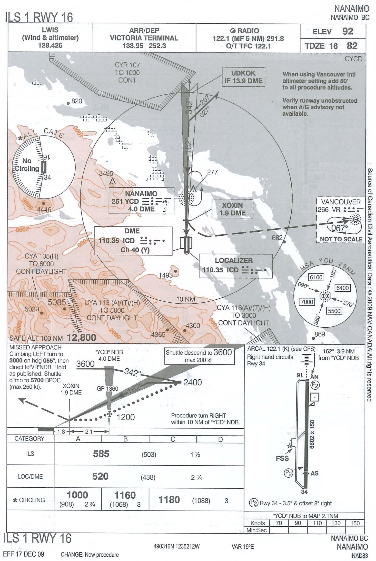
Here's another one that's confused me (I haven't embedded the image as it's massive):
http://www.langleyflyingschool.com/Phot ... S%2016.JPG
As far as I can see, the DH for the ILS is 503ft, but it's 438ft for the LOC/DME, and min visibility is 1.5 miles for the ILS but 2.25 miles for LOC/DME. I'm not really understanding the logic here: you can either use the localizer without glideslope with your DME to get a low decision height but higher visibility, or you can use the entire ILS (but no DME) and you get a lower visibility but higher DH.
Like the OP I don't have an instrument rating yet, so this might just be a misunderstanding, but it just seems weird. Why not have an ILS/DME approach with the lower DH and visibility?
Also note that this is an old chart, and I think they recently changed a bunch of DHs.
Re: Approach plates
The LOC/DME approach isn't "based on" or a "watered down version of" the ILS. Precision and non-precision approaches are both designed to strict criteria taking obstacles and terrain into account, but those criteria are different between the two. So when both are shown on the same plate to save paper there can be apparent inconsistencies.
Finally note that the LOC/DME has a minimum descent altitude, and the ILS has a decision altitude. They don't have the same meaning.
Finally note that the LOC/DME has a minimum descent altitude, and the ILS has a decision altitude. They don't have the same meaning.
DId you hear the one about the jurisprudence fetishist? He got off on a technicality.
-
sidestick stirrer
- Rank 5

- Posts: 383
- Joined: Wed Nov 23, 2005 10:22 pm
Re: Approach plates
My guess would be the difference in the altitudes has to do with the different points where the missed-approach procedure would commence and the different distances from obstacles.
If the ILS let one descend until the typical 200 feet AGL, then the aircraft would be closer to an obstacle than an aircraft commencing a go-around from the LOC-only approach.
If the ILS let one descend until the typical 200 feet AGL, then the aircraft would be closer to an obstacle than an aircraft commencing a go-around from the LOC-only approach.
Re: Approach plates
Yes, looking at the chart you can see that the non precision approach comes in below the glideslope. It just seems weird that a non precision MDH is lower than a DH for a precision approach to the same runway.

Re: Approach plates
You're right, it is weird, but as someone mentioned it has everything to do with the missed approach. On the LOC/DME, you start your missed approach at 1.9 DME, and you can safely operate at the MDA anywhere inside the FAF, as long as you start climbing at the MAP. on the ILS, you start the missed approach when you reach DH, which probably works out to about the same point as the MAP on the loc/DME. If you look at the terrain depiction, you can appreciate why they can't have you wait until you are over the runway to start your missed.CpnCrunch wrote:Yes, looking at the chart you can see that the non precision approach comes in below the glideslope. It just seems weird that a non precision MDH is lower than a DH for a precision approach to the same runway.
In other words, 438 agl is a safe altitude, but if you followed the glideslope until you reached that height, you would be too close to the mountain to do a "safe" missed approach.

Re: Approach plates
To answer the earlier question about using GPS to find waypoints on a non overlay approach: yes you can!
You can use the GPS for anything except lateral guidance on the final approach segment. (So long as it is IFR approved, has a current database, no raim alerts, etc.)
Can you use a GPS to fly a DME arc? Yes!
Can you identify waypoints? Yes!
Can you even identify waypoints inside the FAF, such as step down fixes and the MAP? Yes!
Can you use the moving map with the fancy track lines, obstacles, terrain, and other useful information to increase your situational awareness? Yes!
Can you use the GPS to fly all the way to the MDA without an overlay? No!
Can you use GPS to fly the missed approach? Maybe. Don't bet on it.
And in case you don't believe me, here's my source.
From the AIM, COM section:
3.15.9 Use of GNSS in Lieu of Ground-based Aids
Subject to any overriding conditions or limitations in the aircraft flight manual (AFM) or AFM Supplement, GNSS may be used to identify all fixes defined by DME, VOR, VOR/DME and NDB, including fixes that are part of any instrument approach procedure, to navigate to and from these fixes along specific tracks, including arcs, and to report distances along airways or tracks for separation purposes. This can be done as long as there is no integrity alert, and provided that all fixes that are part of a terminal instrument procedure (arrival, departure, or approach) are named, charted and retrieved from a current navigation database. GNSS may be used to identify fixes defined by ground-based aids, even if they are temporarily out of service.
For example, if the DME associated with an ILS/DME approach is unserviceable, traditional aircraft would be denied the approach; however, under these rules, the pilot of a GNSS-equipped aircraft may request and fly the approach.
Note that for NDB or VOR approaches that are not part of the GPS overlay program described in Section 3.15.5.2.2, pilots shall use ADF or VOR as the primary source for final approach track guidance. For these approaches, and for approaches based on a localizer (LOC) for lateral guidance, pilots shall not use GNSS as the primary source for missed approach guidance when the missed approach procedure requires flying a published track to or from an NDB or VOR. Where ATS requests a position based on a distance from a DME facility for separation purposes, the pilot should report GPS distance from the same DME facility, stating the distance in “miles” and the facility name (e.g. “30 miles from Sumspot VOR”). This phraseology is used for all RNAV systems. When reporting DME distance, the pilot includes “DME” in the report (e.g. “30 DME from Sumspot VOR”). This enables ATS to allow for the DME slant range.
Note that under this approval, there is no requirement to carry the avionics normally used to identify fixes defined by ground-based aids, but other considerations may apply. This topic is discussed in Section 3.15.10.
Re: Approach plates
AOW has hit this on the head.CpnCrunch wrote:Yes, looking at the chart you can see that the non precision approach comes in below the glideslope. It just seems weird that a non precision MDH is lower than a DH for a precision approach to the same runway.
To get obstacle clearance for the missed approach, the minimums for the ILS and LOC/DME have been restricted.
At the ILS MAP, the airplane will be at 503' and 1.42NM from the threshold. At the LOC/DME MAP, the airplane will be at 438' and 1.8NM from the threshold. So the ILS will take you closer, but you need to start the the MAP at a higher altitude since you're closer to the obstacles on the missed approach. This is a direct consequence of the approach being at 3 degrees. Height loss is accounted for when there is a DA as in the case of the ILS approach. A standard missed approach has a 40:1 OCS (obstacle clearance surface) which is equal to 152'/NM. This is also used for a standard 1/2 IFR departure. When flying the required 200'/NM, it provides 48'/NM of obstacle clearance.
If you start drawing lines it'll start to make more sense.
As for using GPS to identify points on the approach, you may do so as another poster commented. The title of the approach (e.g., ILS/DME or NDB RWY 26) indicates the primary navigation type required for final approach lateral guidance. So for my example, you need to use the ILS and DME for final approach guidance or use the NDB for final approach guidance. Both navigation types will have their own minima. But to get yourself to the final approach course, you can use whatever navigation source you have. If there is a GPS waypoint on the final approach course that will set you up nicely for the ILS/DME RWY 26 then fly GPS direct to that waypoint and intercept the LOC and fly the approach inbound.
As photofly said, you will get an automatic 2 on the instrument flight test for not flying a CDFA if appropriate. If you are circling or if you are right above a cloud layer which likely has significant icing in it would be two examples where not flying a CDFA would be appropriate. For the circling you want to get down to MDA as soon as you can so that you have enough room to maneuver and keep the field in sight and also have the airplane trimmed and power set properly so that the flying of the airplane alone doesn't task saturate you. For icing it may be best to descend to the inbound FAF altitude (instead of the recommended CDFA intercept altitude) to intercept the CDFA slope to the runway so that you minimize your time in icing conditions.
“No one can realize how substantial the air is, until he feels its supporting power beneath him. It inspires confidence at once.”
-Otto Lilienthal
-Otto Lilienthal